

 Eat & Drink


 Travel

 Style
Style


 Beauty

 Health & Wellness


 Home & Decor


 Lifestyle

 Weddings


These Hong Kong waterfall hikes are perfect for warmer days! From the popular Ng Tung Chai waterfall to Bride’s Pool at Plover Cove, this guide covers the best waterfall hikes and rock pools in the 852.
Heat and humidity are part and parcel of Hong Kong living. So we’re always keen for a hike that offers a refreshing break at a waterfall, or a natural pool to jump into. Fortunately, our city is home to dozens of cascading waterfalls and rock pools. We’ve compiled a list of some of Hong Kong’s most accessible waterfall hikes that are just off the beaten path. But do keep in mind that the amount of water flowing will depend on how much it’s been raining.
Read More: The Best Beaches In Hong Kong – HK Island, New Territories, Lantau & More
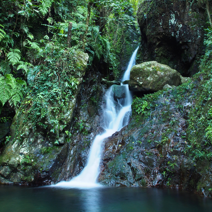
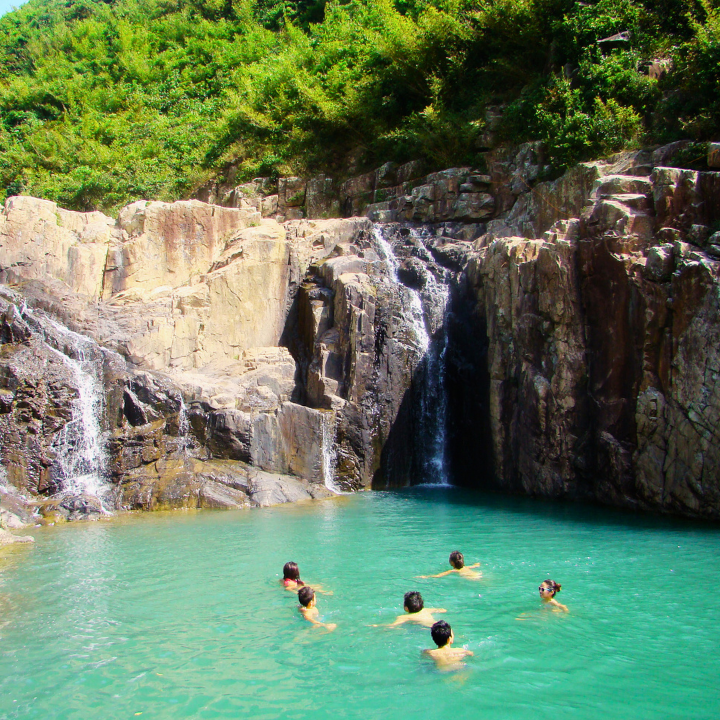
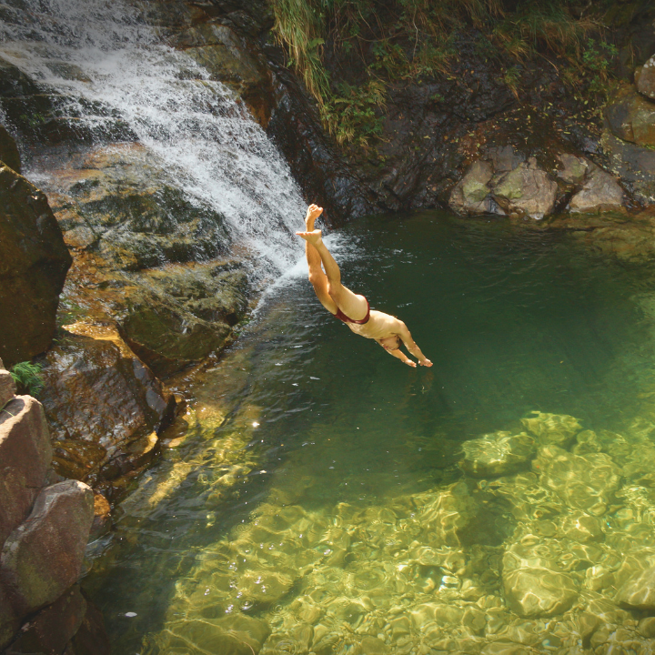
Ng Tung Chai Waterfalls – Home to Hong Kong’s tallest waterfall
Looking for more than one waterfall in one hike? This trail has four. The north-western face of Tai Mo Shan, Hong Kong’s tallest peak, boasts some of the most spectacular waterfalls in the city, with the highest being 35 metres tall. It’s the perfect place for a swim in the natural pool and a picnic, with a cultural stop at the Man Tak Yuen temple along the way.
How to get there: To reach the lower waterfalls, take minibus 25K from Tai Wo Station to Lam Kam Road. Disembark and walk for about 10-15 minutes until you see a path branching right past the village houses. Follow it straight to Man Tak Yuen Temple, continue beyond it to reach Bottom Fall – the first cascade on the main trail. The path gets much steeper after Bottom Fall, but leads to the most spectacular falls and rock pool!
Length: 3km (one way)
Time at a leisurely pace: 2 hours
Difficulty: Intermediate to advanced (depending on which waterfalls you tackle)
Avoiding wrong turns: Stay on the main path. It takes you to all of the falls and is much less slippery.
Getting home: Best to retrace your steps back. Option two is to continue hiking up to Tai Mo Shan until you reach the Rotary Club Campsite, where the trail ends. From there, catch bus 51 to Nina Tower Bus Terminal, Tsuen Wan, then transfer to the MTR.
Read More: Swimsuit & Bikini Shops — Where To Buy Swimwear In Hong Kong
Ping Nam Stream – Lesser-known Hong Kong waterfall and rock pool
This scenic hike takes you up near Wilson Trail section 10, offering an off-the-beaten-track experience as you traverse rocks and streams to reach a breathtaking waterfall. Along the way, you’ll encounter Hula Skirt Fall followed by Twin Falls, all while enjoying stunning views of Nam Chung Trail and, on clear days, even catching a glimpse of Shenzhen in the distance.
How to get there: Take minibus 56K from Fanling MTR heading towards Luk Keng Road (鹿頸路). The stream will be around 40 minutes ahead. When you reach an intersection, turn right and go straight until you reach the dam. Follow the stairs on the right and turn left at the top. Continue alongside the railing and turn left onto a dirt road before heading down towards the stream.
Length: About 6km
Time at a leisurely pace: 5 hours (including time for pictures and a dip in the rock pool!)
Difficulty: Intermediate
Avoiding wrong turns: At the dam (2.5km from the bus stop), don’t attempt to jump the fence! Instead, climb the stairs on the right, turn left at the top and follow the railing. Then, take another left and look for a loosely defined footpath going through the bushes, which is the correct route.
Getting home: Return the same way you came.
Read More: 50+ Free Things To Do In Hong Kong
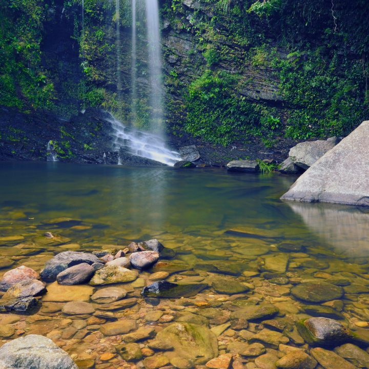
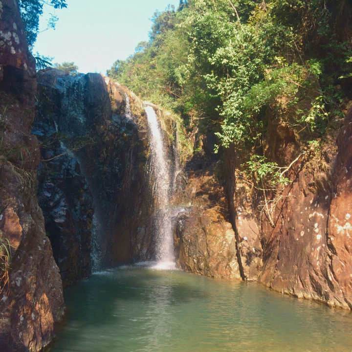
Bride’s Pool – Scenic waterfall and nature trail near Tai Mei Tuk
Urban legend has it that Bride’s Pool got its name from a bride who fell into the pool when she was being carried in a sedan chair during stormy weather. Today, there is a clearly marked, paved and flat path to get to the falls – phew! There are some beautiful trails around Plover Cove, so it’s worth using these as brief picnic and snack stops during a full day of wandering in the area.
How to get there: From Tai Po Market MTR station, take minibus 20R to Bride’s Pool Road (新娘潭路). Once you arrive at the stop, you’ll find clearly marked paths for the Bride’s Pool Nature Trail. Proceed past the trailhead, descend the stairs and cross the bridge. Take a left to reach the falls.
Length: Less than 1km to Bride’s Pool and less than 1km beyond that to Mirror Pool
Time at a leisurely pace: 30 to 45 minutes (one way)
Difficulty: Beginner
Avoiding wrong turns: As there are so many trails around here, directions are clearly signed.
Getting home: Call or hail a taxi from the trailhead if there are no buses, or walk down the same way to reach Tai Mei Tuk Tsuen — a nice waterfront area filled with restaurants and bike paths. There are buses or taxis to take you back to the MTR from there.
Read More: The Best Beachside & Seaview Restaurants In Hong Kong

Silvermine Waterfall – Brisk hike to three sets of waterfalls near Mui Wo
An easy waterfall hike from Mui Wo Pier, Silvermine boasts three tiers of waterfalls perfect for the wet season. The Lower Silvermine, Pearl and Main waterfalls are all heavily dependent on rain, so there isn’t much opportunity for swimming in the rock pool during summer – make the most of your trip by visiting in the wet season instead.
How to get there: To reach the waterfalls and Silvermine Cave, start by walking towards the beach from Mui Wo ferry pier. Follow the beach until you reach Silvermine Beach Resort. Just before reaching the resort, take a left turn and continue straight. Along the way, you will find signs guiding you to the waterfalls and the shuttered Silvermine Cave.
Length: About 3km (one way)
Time at a leisurely pace: About an hour
Difficulty: Beginner
Avoiding wrong turns: Be mindful when you reach a fork in the path approximately 300 metres after leaving the beach. Stay to the left of the creek and continue on the left path.
Getting home: While there may be longer hiking paths connected to these trails, for a shorter trip, returning along the same path is the easiest option.
Read More: Your Ultimate Hong Kong Hiking Trail Bucket List
Ma Dai Stream – Tranquil and accessible waterfall in Ma On Shan
Ma Dai Stream, also known as Tai Shui Hang, is located in Ma On Shan Country Park in the New Territories and is one of Hong Kong’s best-kept secrets. While canyoning and sliding through the water are possible here, it’s essential to engage the services of an experienced guide. However, you can still enjoy the beauty of the waterfall with a relatively short hike, although be prepared to get wet as you navigate over rocks.
How to get there: Take the MTR to Tai Shui Hang and leave at Exit B. Head left and follow along Hang Tak Street. At the end of the path take the road on the right, which will lead you to a dam. The trail towards the stream will be on the left, just before the dam. Following the trail, turn left at the end where you will see another dam and bridge. Cross the bridge, turn left and you will arrive at the entrance of the stream and the beautiful Hero’s cliff.
Length: Approximately 5km
Time at a leisurely pace: 2 hours (one way)
Difficulty: Advanced (may require climbing on all fours)
Getting Home: To return, continue following the path until you reach a fork. Take the left turn and proceed past the private farm onto Man On Shan Country Trail. Pass the picnic area, turn left onto Man On Shan Tsuen Road, and follow the directions to Heng On MTR station.
Read More: The Top 15 Picnic Spots In Hong Kong
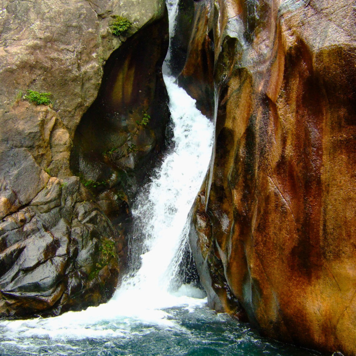
Sheung Luk Stream – Natural rock pools in Sai Kung
Sai Kung hikes are gorgeous and this tiered series of waterfalls and natural pools hidden in the hills between Sai Wan and Ham Tin beaches in the Tai Long Wan cove are especially breathtaking! They are a perfect side stop for a day trip to the beach or during a camping weekend.
How to get there: From Sai Kung town, take minibus 29R or a taxi to Sai Wan Pavilion. Then hike 40 minutes to Sai Wan beach, sticking left until you reach the end of the stream. Continue another 15 minutes into overgrown shrubs, with fenced farmland on your left, to find the falls.
Length: 3.5km (one way)
Time at a leisurely pace: About an hour
Difficulty: Intermediate
Avoiding wrong turns: There is a cement footbridge that crosses the river – don’t go over it. Stay on the path to the left.
Getting home: Either hike back along the same route you came or arrange for a sampan boat ride. The sampan ride typically takes around 45 minutes and costs from $100, departing from Sai Wan or Ham Tim, the neighbouring beach in the inlet. Best to make arrangements for the boat before leaving Sai Kung town, as they can fill up quickly.
Read More: Stunning Sai Kung — Best Spots to Eat, Stay and Play
Tai Tam Mound Waterfall – A hidden waterfall in Tai Tam
This hidden gem, tucked away on Hong Kong Island, promises a rewarding payoff for minimal effort. It’s just an easy hike along Section 6 of the Hong Kong Trail until you reach the cascading waterfall – keep an eye out for the rocky path leading down to the main event. Soak in the soothing sounds of rushing waters as you admire the natural scenery. Just resist the temptation to take a dip in the rock pool, as swimming is off-limits to preserve the reservoir’s drinking waters.
How to get there: From Sai Wan Ho MTR station (exit A), take bus 14 to Tai Tam Reservoir (North) stop.
Length: 1km from Tai Tam Reservoir
Time at a leisurely pace: Around 20 minutes
Difficulty: Beginner
Avoiding wrong turns: Enter Tai Tam Country Park, pass two bridges, then take the rocky path down on the left before the third bridge.
Getting home: Return the same way.
Read More: Where To Buy Athleisure In Hong Kong
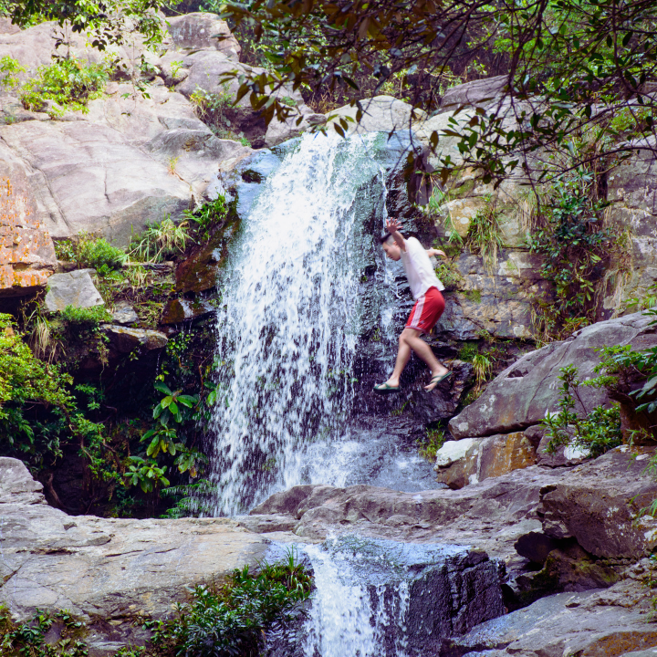
Little Hawaii Trail – A waterfall hiking path to Lin Yuen Terrace Falls
The well-paved path winds through vibrant greenery before dropping down to the main sight – the charming Little Hawaii Falls. Though the top waterfall may not impress, press on downstream to uncover the true star – the magnificent Lin Yuen Terrace Falls. With bubbling currents and blue-green nature pools, this postcard-perfect scene begs for a refreshing swim!
How to get there: From Po Lam MTR station, take exit C and make your way to Po Hong Road towards Tseung Kwan O Village. Follow the path leading to Au Tau, and you’ll spot the starting point of Little Hawaii Trail.
Length: About 2.5km
Time at a leisurely pace: 2 hours
Difficulty: Beginner
Avoiding wrong turns: Follow the well-marked Little Hawaii Trail, taking the right turns at any junctions or crossroads, and continue along the main path while listening for the telltale sounds of the bubbling stream until you reach the picturesque destination.
Getting home: Simply retrace your steps back to the cross junction, then turn right to follow the steps leading down to Tseung Kwan O village. From there, the closest MTR station for your journey home is Po Lam station.
Wong Lung Hang Stream – Picturesque waterfall trek near Tung Chung
This hike is made all the more exciting by the fact that you can actually trek through the stream! Wong Lung Hang or Yellow Dragon Stream is one of Hong Kong’s most scenic, introductory-level stream treks. Lung Mei Falls (Dragon’s Tail Falls) is surrounded on all sides by waterfalls and there you will see several cascades where climbing with ropes is possible – but this is best left to experienced climbers.
How to get there: From Tung Chung MTR, walk to Fu Tung Plaza and take New Lantau Bus 11 to Yu Tai Court. Then, walk 30 minutes to Wong Lung Hang Picnic Area. Follow the trail down to the stream, go left down the slope and continue towards the stream. Cross the pool via the right dam to reach the falls.
Length: About 10km
Time at a leisurely pace: 3 hours (Wong Lung Waterfall is 2 hours into the trek and 1 hour into the stream, where there is a really nice rock pool for swimming!)
Difficulty: Intermediate
Avoiding wrong turns: There are a few smaller streams merging into Wong Lung Hang but you must stay on the main stream.
Getting home: Head back the way you came and take the MTR from Tung Chung.
Read More: The Top 15 Picnic Spots In Hong Kong

Tai Yuen Stream – Waterfall hike for daredevils and nature lovers
This is another series of falls in the Tai Mo Shan area with a stream running from Tai Mo Shan to Yuen Yuen Institute. Two waterfalls, Cliff of Flying Monkey and Jumping White Dragon are some of the standouts on the hike, however getting there requires a steep scramble and is definitely for confident and competent climbers.
How to get there: From Tsuen Wan MTR exit B2, head towards Shiu Wo Street (兆和街) to catch minibus route 81. Get off at the final stop, which is Western Monastery on Lo Wai Road (老圍路). The trail towards the stream begins at the back of Yuen Yuen Institute, where you will find a footpath leading to the stream. Follow past Lo Wai Village and you’ll come across the catch-water facilities of Tai Yuen Stream. Continue onwards to reach the stream.
Length: 2km
Time at a leisurely pace: 40 minutes from Yuen Yuen Institute
Difficulty: Intermediate to advanced (the path can get very slippery!)
Avoiding wrong turns: Stay on the right path by following the stream throughout the hike.
Getting home: Retrace your steps.
Sassy Tip: Before embarking on any hike, it’s essential to research the trail’s difficulty and take necessary precautions. Be mindful of these factors:
- Check the weather forecast.
- Carry sufficient water.
- Wear appropriate clothing and footwear with a good grip.
- Stay on the designated path.
- Ensure your mobile phone is charged for emergency situations.
For more hike options, we’ve got a list of shaded hikes, beginner hikes, hikes under two hours and hikes to get you to the beach!
Editor’s Note: “Best Waterfall Hikes And Rock Pools In Hong Kong” was most recently updated in June 2026 by Suchetana Mukhopadhyay. With thanks to Eleni H and Fashila Kanakka for their contribution.
Main image courtesy of Suchetana Mukhopadhyay, image 1 courtesy of Pak Ling Lie via Flickr, image 2 courtesy of Nikolaj Skov Jespersen via Flickr, image 3 courtesy of Lui Raymond lui via Flickr, image 4 courtesy of My Pixelated life via Flickr, image 5 courtesy of 攝影 札記 via Flickr, image 6 courtesy of Jerome Taylor via Flickr, image 7 courtesy 長期 梁美 via Flickr, image 8 courtesy of seaonweb via Getty Image, image 9 courtesy sch0705 via Flickr, image 10 of 香港山友行山遠足分享群 via Facebook.