


 Eat & Drink


 Travel


 Style
Style


 Beauty


 Health & Wellness


 Home & Decor


 Lifestyle
 Weddings


One would think hiking Hong Kong’s tallest peak is only fit for seasoned climbers – we break down five ways to reach the top of Tai Mo Shan, in varying levels of difficulty.
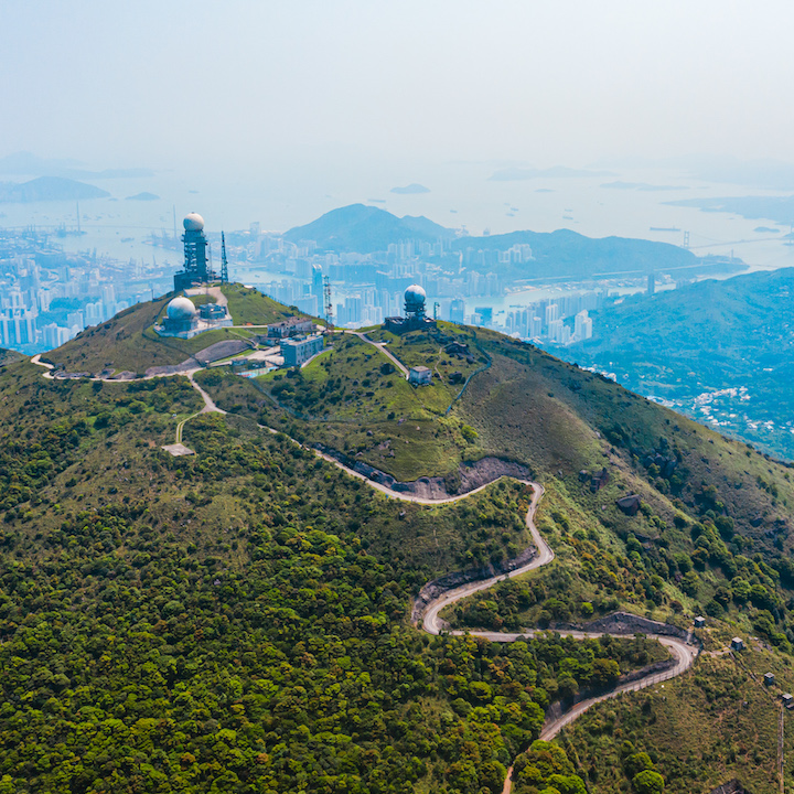
Tai Mo Shan (大帽山), translating to “Big Hat Mountain” is, in fact, an inactive volcano, standing at 957 metres above sea level, making it the highest peak in Hong Kong, and the ultimate hike to tick off your bucket list. But don’t let that fool you into thinking it’s not suitable for beginners or for a quick hike.
While cabbing to the top is an option (but where’s the fun in that?), there are hidden paths, twists and turns that will take you to the glorious viewpoint of Tai Mo Shan minus the treacherous climb. But if partaking in a challenge is your forte, grab those hiking boots, the mountains are calling! Ahead, we highlight five ways to climb up to Tai Mo Shan, each suitable for different hikers.
Read More: Best Hong Kong Hikes – Your Ultimate Hong Kong Hiking Trail Bucket List
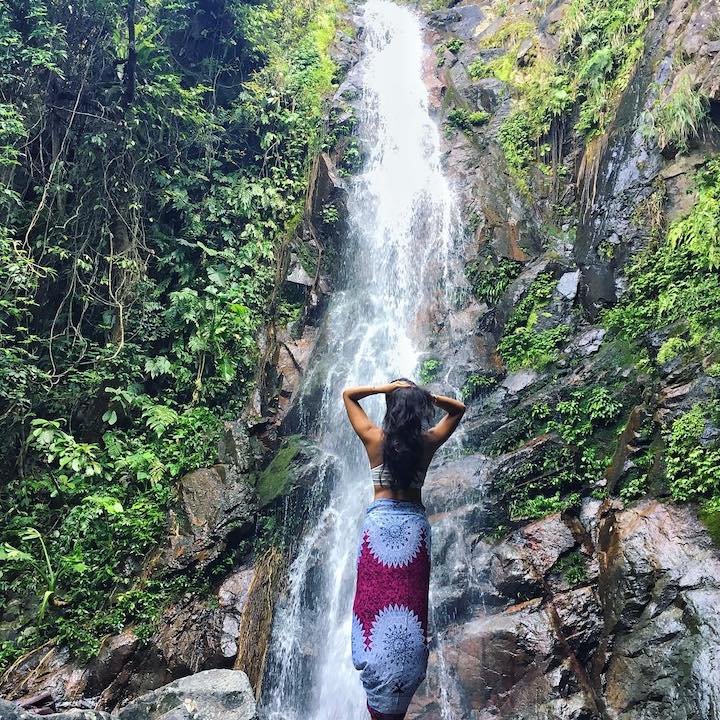
Route 1: Ng Tung Chai Waterfalls Route – For Summer Hikes
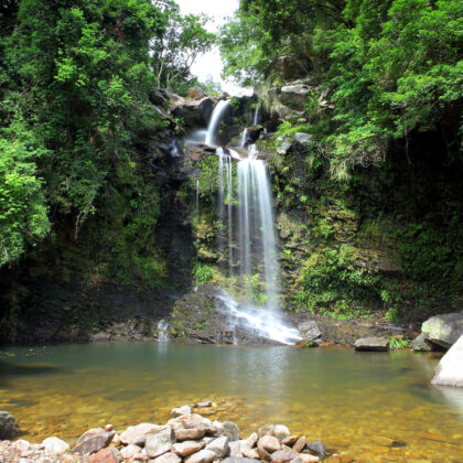
A popular trail to go up to Tai Mo Shan – the Ng Tung Chai waterfalls trail is shaded and perfect to tackle in rainy and warm season. It takes you through a total of four waterfalls; Bottom, Middle, Main (highest), and Scatter, and it’s basically a walk through the jungle – do wear shoes with good grip as it get can very slippery around the rocks towards the waterfalls.
Difficulty: Intermediate to advanced
Duration: About 5 hours
How to get there: Take bus route 64K from Tai Po Market Station (East Rail Line) and alight at Ng Tung Chai Bus Stop.
Read More: The Best Waterfall Hikes In Hong Kong

Route 2: MacLehose Trail Stage 8 Route – For The Early Birds
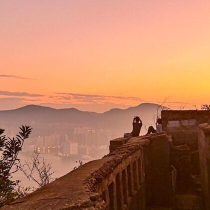
Early bird catches the worm – and magnificent sunrises from atop Tai Mo Shan! This path connecting Lead Mine Pass in the east to Route Twist on the west is the best option for those seeking the first light of dawn as it’s a concrete path that’s still visible in limited light. Don’t forget to pack your headlights though!
Difficulty: Intermediate
Duration: About 3 hours
How to get there: Take minibus route 23K from Tai Po Market Station to San Uk Ka. And then walk for about 15 minutes to Yuen Tun Ha until you reach the Wilson Trail starting point to Lead Mine Pass.

Route 3: Rotary Park To Tai Mo Shan Viewpoint – For Beginners
This is the path for anyone that wants to say they’ve conquered Tai Mo Shan – minus the treacherous, long climb! The perk of this route is, the starting point is already 470 metres above sea level so when you start, you’re already halfway there! Starting off with relatively steep steps, the path eventually becomes a concrete road with a gradual and leisurely climb.
Difficulty: Easy
Duration: About 1.5 hours
How to get there: Take KMB bus route 51 from Nina Tower Bus Terminus (Tsuen Wan West Station) and alight at Tai Mo Shan Country Park. Follow the signs pointing to the visitor centre.
Read More: 6 Short Hiking Trails In Hong Kong – Easy Hikes Under Two Hours
Route 4: Route Twisk To Wo Tong Kong Hidden Trail – For The Road Less Travelled
A little detour, this path will not take you to the weather station but if you’re hiking between November and January, this is a must-do pit stop for anyone and everyone that loves silver grass! You’ll need to first walk past shrubs to eventually get to the terrain filled with silver grass, as well as interesting rock formations from the Jurassic period. There are ribbons tied to trees to mark the path, as long as you don’t steer away, you should be on track.
If you’re looking for dreamy wedding photography, this path will hit all the notes and more!
Editor’s Note: There’s no trail connecting this path to the viewpoint of Tai Mo Shan so you’ll need to go back the same way.
Difficulty: Beginner to intermediate
Duration: About 3 hours
How to get there: Hike from Route Twisk to Wo Tong Kong, there’s a path to the right that starts off quite steep.

Route 5: MacLehose Trail Stage 7 And 8 – For The Seasoned Experts
Tackling Tai Mo Shan is no easy feat and for those looking for an added challenge, this trail takes on not only Tai Mo Shan, but also Needle Hill and Grassy Hill – that’s three peaks for you! The sweeping views, mixed terrains and elevation keeps the momentum going even if it seems to be an endless hike – also a good challenge for trail runners who can complete this hike in about 4 hours.
Difficulty: Advanced (not advised for beginners to attempt)
Duration: About 6 hours
How to get there: From Tsuen Wan MTR Station Exit B, walk over to Shiu Wo Street and take minibus route 82 to Shing Mun. Alight at Pineapple Dam and walk over to Jubilee Reservoir to start the hike.
Read More: The Hardest Hong Kong Hikes To Tackle This Year
What To Know Before Hiking Tai Mo Shan
When To Hike Tai Mo Shan
The answer – basically any time of year! But given its altitude, the top is often a sea of clouds so it’s best to avoid humid weather (especially in spring and summer). Set off in winter when it’s relatively dry and cool to catch the panoramic views on the way up as well as from the top.
Flora And Fauna In Tai Mo Shan
Hikers can spot groves of Taiwanese cherry blossom trees by the Rotary Park which bloom in February and March. There are also more than 100 bird species and plenty of butterflies. Stay wary of snakes including the White-spotted Slug Snake, Red-necked Keelback, Bamboo Snake and Common Rat Snake!
Can You Cab It Up?
Yes, you can cab it or drive up and park next to the visitor centre that also has plenty of information on the history of Tai Mo Shan. But do note that this is not the summit of Tai Mo Shan and you’ll still need to do a short hike to get the highest viewpoint.
Is There Anywhere To Eat At Tai Mo Shan?
It is a hike after all and a long one at that, so be sure to pack snacks, lunch and adequate water. The only place to buy food is the snack stand run by Aunt Lin at the Tai Mo Shan visitor centre. You can also opt for a dim sum lunch at Tuen Kee Dim Sum at Chuen Lung Village either before or after your hike.
Read More: The Best Cycling Trails in Hong Kong: Where To Ride Your Bike
Main image courtesy of @_852.carlo via Instagram, image 1 courtesy of @christine.choux via Instagram, image 2 courtesy of @anguswphotography via Instagram, image 3 courtesy of @anguswphotography via Instagram, image 4 courtesy of @anguswphotography via Instagram, image 5 courtesy of Getty.